Curiouser Still…

__mudflood antarctica3

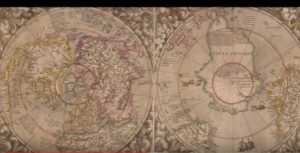
This 16th century map shows land at the north polar region, plus several islands that ‘don’t exist.’ More in the linked videos below.

Now that I think about it, whenever I pre-judge someone based on something ‘odd’ they are doing I ought to back up and think about whether I know anything about the odd thing they’re doing. Last night, for instance, I’d set my alarm for 3 AM so I could go out and change the batteries in my sky-lapse cameras. I’m fiddling with the stuff wearing a flashlight on my head in the wee hours, right? Someone happened to notice me, what are they going to think? ‘What’s that goofball doing?’, right?

But what’s my point?
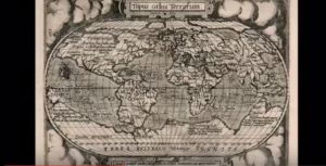
_mudflood 1574

This map from 1574 is very strange in that it should not exist. The famous ‘Piri Reis’ map is just the tip of the cube.

You go to the beach you’ll often see people with metal detectors: ‘There’s another goofball’ being my typical reaction. Yesterday I saw a woman metal detectoring the desert nearby so I went over and struck up a conversation. Didn’t take long before I realized that my goofball judgment of metal detecting folks was incorrect. I mean how is what she was doing any different from my sky-lapses? We both use technology to see what we can learn about HTWRW. I look up, she looks down.

‘As above, so below’ actually occurred to me as I spoke to this woman about the stuff she’s found over the years, including artifacts of unknown origin. She and her husband are from Montana, he being a retired logger. They’ve been traveling around for a few years, as i have been, seeing what they could see, including stuff they find under the ground.
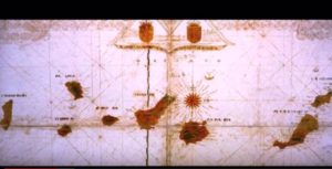
_mudflood canaries1

There is a Canary Island on this map that should not be there, never should have been there. How can all these cartographers be so wrong?

About 10 minutes into our conversation I decided I had to buy a metal detector. The couple is going to help me get the hang of it. I watched a few tutorials on Amazon, did some searches, and found there’s a subculture out there of folks who comb the underground for weird stuff. My kind of folks. So in spite of my iffy finances I’ve ordered a Garrett Ace 300 Metal Detector ($260) and will get back to you guys when I’m rigged up and actively detecting.
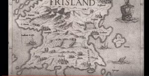
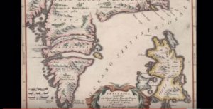
_mudflood frisland2

Before it ‘disappeared, Frisland was on all the maps of the North Atlantic, pre-18th century. Mandela Effect nutcases would call this ‘residue.’

As above, so below. Yeah, definitely. Looking back at the places I’ve been, especially those outback areas with strange rock formations that just maaaaybe are not so natural, who knows what I might have unearthed, had I had a Garrett Ace 300. When you look into the geological history of this planet — yeah, I mean really look into it — you come away just knowing that there is a whole other history down there under the patina where earth ends and sky begins.

Perhaps not coincidentally (given my ‘as above, so below’ revelation plus my Ace 300 purchase), yesterday ‘Kevin’ reminded me of a subject I’d looked into a while back but then got distracted… probably by the Spacex fraud, now that I think about it….
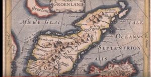
_mudflood greenland 1600s no ice

One odd thing about these maps of Greenland et al is that there is no ice, no glaciers, and many towns where now there is a mile of ice.

I’m talking about the ‘mudflood’ issue, another one of those weird, possibly spooky deals, like the Mandela Effect (I really hate that moniker, plus the idea that one might ‘suffer from’ it). In fact, the ME could be one of the possible explanations for the mudflood evidence. In brief, I’m talking about the evidence that certain cities worldwide have been inundated by what appears to be mud flows. Sometimes completely, but more often only partially buried, then built up again over the ruins. Check out the adjacent images for what I mean. How many of you have looked into this?

_mudflood greenland 1600s no ice2

Still another example of a world that ‘never existed.’

The strange thing — and why I even bring up the ME — is that the phenomenon seems only to have affected cities, which, if true, is inexplicable. The other thing is that, whatever is going on, it was not that long ago. Like one or two hundred years. I spent much of yesterday viewing the video series I’ll link you to below. I got even more interested when the videos segued to ancient cartography and the horrendous anomalies uncovered, especially if you go back to the 14th, 15th, 16th, and 17th centuries. I’ll reproduce some of the maps. Notice Greenland, for instance — the forests and rivers depicted, where now we have miles of ice. Greenland isn’t currently green at all, is it?

How did Greenland get its name, given it’s been covered with ice for hundreds of thousands of years? (‘To attract settlers’? You believe that?) See, if you look at the old maps, it was apparently green, and I’m talking about only a few hundred years ago. This is why I bring up the goddamn Mandela Effect. See, something is so wrong here that we cannot explain it in… ways that ‘make sense.’
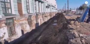
_mudflood3

A possibly related subject is the worldwide ‘mudflood’ that has left evidence like this. It sure looks like what’s underground now used to be the first floor, street level.

Addendum: I’m at the very beginning of looking into this subject and should point out that I was severely disappointed toward the end of the third video, when the narrator brought up flat earth; he even recommended moles like Eric Dubay and fucking Jeranism (whom I’ve seen fit to blog about as a flat earth disinfo mole). 
_mudflood trailer

I wouldn’t bring any of this up except for the mountains of ‘residue’ that point to a different history altogether from what we’ve been told.

Then, in another video, he started in on numerology, which, as a subject, I’ll not denigrate (out of ignorance), but when he listed about a score of NWO folks whose names all added up to 33 or 44 or the like, I got suspicious. He was displaying his numerology calculator and when I tried to find it online so I could check his findings (if they are genuine, it’s a total mind bender), I kept getting ‘Download for Free’ websites, which I do not trust. (If the calculator is genuine, why wouldn’t someone put it on a website for researchers?)

But I checked some of the cartography claims and they are genuine. Even Wiki defines them as legit, they of course omit mentioning the horrendous anomalies. So for now, let’s suspend negative judgment.  

And then there’s ‘Frisland,’ an island that appears on all the maps of the 15th – 16th centuries, but then suddenly ‘disappeared.’ If there was only one disappearing island I’d write it off (somehow), but there are several others that went poof! at about the same time.

And then there’s the matter of Tartaria…

Although the videos don’t bring up the Mandela Effect, you can maybe see why I do. When there are ‘glitches in the matrix’ of this magnitude and variety, they become paradoxes/enigmas on a whole other level.

Addendum: Those of you who like to ‘hand wave’ away the Mandela Effect as being based on faulty memories, I assume you will explain the ancient maps in a similar way, i.e., all the expert cartographers from the 14th through 16th centuries made the same horrendous errors, and were not corrected by contemporary sailors/explorers. 
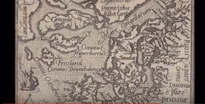
mudflood greenland 1500s

Still another one, including Iceland, Greenland, and ‘Frisland’, an island that the PTB say never existed.

I’m going to look further into this but enough for now. I’ll supply some links, if you’re curious (and you should be), if only to explain how Greenland suddenly became buried under hundreds of thousands of years’ worth of ice, in two or three hundred years.

Allan

The fellow who calls himself Life Kreationz by David Wells has a series of videos, starting here, with the ‘mudflood’ phenomenon. His next video plus this one zeros in on the Greenland/Iceland enigmas, asking how the glaciers and ice sheets could have been absent in the geologically recent past. Then he goes on to other disappeared land masses. I suggest you give this subject some time; it ain’t easy. And even if Life Kreationz by David Wells is some sort of limited hangout/disinfo agent, the enigmas he describes are real, and in my view, are possibly ‘macro’ versions of whatever the Mandela Effect actually represents.
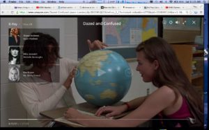
 

____MANDELA DAZED PIC copy 2

I’ve showed you this frame from an old movie a couple of times. Notice the island west of Oz?See the connection with the above enigmas, and the ME?

Addendum: Big, big thanks to ‘Joseph’ for the amazing work he’s done in cataloging my various blog links, recommended readings and so forth. As soon as I figure out the best way to do it, I’ll be adding Joseph’s documents to the blog, maybe via the sidebar. 


  26 comments for “Curiouser Still…

  1. Horst
    January 17, 2020 at 1:47 pm

    The photo presented here for evidence of the mud flood has been researched, it is just a basement with some daylight:
    https://web.archive.org/web/20160721021238/http://top55.info:80/news/newsid/61046/
    Some of the mud flood evidence pictures are just shopped.
    I was into this in late 2018, listening to Max Igan. I was interested in the questions itself, watching it regardless there is not much substance. There is a pattern, as in FE, the missing substance is always substituted with talk about “to free your mind” and “think for yourself”.
    Not mocking, history has been made up. I never understood, why archeology always has to dig. How to get to the truth? We can`t know, but we can get a clue by looking at language (root language), legends, tales, and The Bible. As done here, just skip the FE pragraph on top.
    https://rosettedelacroix.com/?p=29107
    Maybe our world has been turned upside down, literally. Work in progress, the ME ties into it.

  2. frank
    January 17, 2020 at 7:21 am

    Allan, sounds like you already know the http://www.stolenhistory.org website.
    If not, it is a recommended read. They discuss odd topics, such as the maps you mentioned. And while not all agree on one theory, the common tenor is that there is something seriously wrong with the history we are being told.

  3. Mary Louise Phelan
    January 16, 2020 at 9:53 pm

    Greenland, when Norse settlers came they went to the very small parts of Greenland that did have forests and since it was the sort of land it is, the forested areas were 1. small and 2 . took a very very long time to grow. But the Norse did NOT change their ways (they did not live like the indigenous peoples who did live there and had sustainable manners of being on that sort of land.) The Norse used ALL the wood, chopped down ALL the trees and eventually starved to death. All history that has been documented, recorded and exists in many places BUT a succinct account that is referenced is in the following: Diamond, Jared (2005) Collapse (How Societies choose to Fail or Succeed) Page 211. Viking Press

  4. Jean-François Aubry
    January 16, 2020 at 8:53 pm

    Hey…next summer (we have a foot or 2 of snow here) i also plan to bought a metal detector….some meteorit worth much more than gold…and you can also find cool weird metal artefact

  5. GB
    January 16, 2020 at 8:34 pm

    Allan If you are interested in Friesland and other lost lands – and the speed with which they disappeared, I can recommend Jan Ott’s https://fryskednis.blogspot.com for his excellent work researching (and producing a new English translation of) the Oera Linda book. No hidden agendas here. Just quality research of a book and a folk memory that sits at odds with much of what we have been told about the bronze age.

    • January 16, 2020 at 9:13 pm

      I had problems with the foreign language and am not sure what he’s getting at. Anyway, Frisland is one example of the map anomalies; I have a lot more reading to do on this. For now, I’ll concentrate on Greenland, given the mult-layered anomalies. It would be good to find some original writings of the explorers from pre-19th century, going back as far as possible. If they indeed say that Greenland was ‘green’, with rivers and forests (which is what is on the maps), then we have a real conundrum, don’t we?

  6. Andrew
    January 16, 2020 at 4:51 pm

    Ah, a Garret Ace 300, cool! I’m excited to see what you uncover. If you haven’t watched The Detectorists on BBC check it out.

    Really interesting post. We spoke about this a few months back in relation to mariobuildreps’ take on Greenland –

    https://mariobuildreps.com/greenland/

    Crustal shifts and pole migration are his conclusions, may be worth revisiting. If we were to sync his science with some of your thoughts it would mean those maps are very, very old.

    Re missing landmasses there is a part of Northern Holland known as Frisland. I’ll look into any possible relation.

    And I’ve shared some of Tommy’s stuff with you before and only do so again now because it is relevant – tonight at 730 EST he will begin a re-broadcast of his From Russia With Love series. Parts 1 (tonight) and 2 cover the Slavic Aryan Vedas with many references to landmasses north of the Siberian Continent. https://www.spreaker.com/user/8955881

    • January 16, 2020 at 7:05 pm

      Great comment. That first link is very important, even if it isn’t 100% on the money. Here are some excerpts from it that are of interest [with comments]:

      Why did this accumulation of ice not happen in similar regions of Alaska, Canada, or Russia, where the much colder land climate has an even better chance to build up an ice sheet? Strangely, this is never mentioned in their theories. [No mainstream theory can explain why Greenland has it’s huge ice sheet but other northern areas do not.]

      Drill samples have shown that the Greenland ice sheet is approximately 110,000 years old. Other estimates claim that the ice sheet is almost 400,000 years old. How did this ice sheet become so large, while the surrounding countries with mountain ranges, like Alaska, Canada, and Russia, have no ice sheet? Even Iceland is not fully covered in ice. Moreover, the exact age of the ice sheet is unclear. What do we really know? [This is where the anomalous old maps are relevant. Absent something very highly strange, we cannot reconcile the age of the sheets with the old maps. Unless ALL the cartographers (including Mercator himself) were all drunk or nuts.]

      The eccentricity of ice formation around the North pole is caused by deformations of the crust, which causes large bodies of ice to be transported to locations where they were not “created”. The ice sheet on Greenland would not be there if the geographical pole always had been where it is today. There is simply no scientific explanation possible without the introduction of a radical shifting mechanism of the Earth’s crust. [What this excellent research leaves out is possible solar influences, like a micro-nova event, which would have briefly boiled, say, the Pacific, which would cause huge amounts of water to turn to steam/clouds, which then would COOL the planet, with snowfall and ice formation forming various ice sheets (including the North American ice age sheet. Whew. Not easy to sum it up but this theory is explained on suspiciousobservers.com. Takes some time to get thru it but well worth it. I’ll do a post.]

      Paleomagnetists assume that, when they look at the samples of alleged magnetic pole reversals, that the magnetic pole was the only variable that changed, however, there is no way to tell from the samples what exactly had changed – the magnetic pole or the crust. Because the magnetic pole obviously moves, it does not mean the other variable, namely the crust, is rigidly fixed. That is an unscientific assumption. [They theorize that Greenland was once at the geographic north pole.Could be!]

      Our large article on the main page shows the amazing orientation patterns of more than 910 ancient structures that are spread around the world. These 900+ pyramids, temples and structures point to three different, clear polar locations on Greenland, and exactly at the same region that was already centrally embraced by the ice sheets of the last glacial cycle.

      This does not only show an amazingly precise orienting of pyramids and structures around the world, but it also proves that these pyramids are much older than Academia had always assumed because these ancient pole positions are not just a few thousand years old. [This I haven’t heard before and will have to check out]

      Anyway, I’m going to be a busy boy today. Thanks again, Andrew.

  7. Paul
    January 16, 2020 at 4:31 pm

    I made it 12 minutes through the first mud flood video. All he’s got is some pictures of buildings with basements. Does it really get better? It’s common architecture to build a structure with basements and below ground windows in light wells to let natural light in. See that a lot here in Oregon. Not evidence of a mud flood at all IMO.

    • January 16, 2020 at 5:04 pm

      Waking up to dumb comments (the first three, from Paul and good old Barbara Muller) is not the way to start one’s day. These are perfect examples of what I have asked you not to do: Make negative comments – or any comments – before looking into the matter discussed. Keep it up and you will be deleted.

  8. Paul
    January 16, 2020 at 4:22 pm

    Regarding Greenland. I asked questions forty years ago to teachers and professors about why Greenland? I was told that it was called Greenland to steer people there, away from Iceland. Because Iceland was a fabulous place. Iceland was for the privileged/fortunate, and Greenland for the lesser ones/the undesirables.

    Postscript/context: I am not writing to be dismissive about anything written about Greenland in the blog or the maps or cartography changes, I’ve been aware of the ME since the early 2000’s. I’d go to Barnes and Noble several times a week (divorced father, 2 daughters, our library) and was amazed that the Bear books would change names back and forth (e.g., Stein to Stain).

    When I was about 15 1/2 I had a revelation about HTWRW. Because it deals with beliefs and faith I won’t write more beyond I’ve studied in-depth and at-length ME and the bibles. I think Allan, and many of the commenters, are asking important questions. Questions that can lead to plausible answers. The ME is not an isolated phenomenon. Everything is correlated. What’s happening on your site is we’re trying to figure out legit cause-and-effect.

    • January 16, 2020 at 8:57 pm

      Re Greenland’s name, I do ask in the essay whether the reader believes that the name is a PR maneuver (from like 400 years ago) to get folks to go settle there. If that was the only anomaly I’d write off the misleading name; but when you combine the name with all the maps showing rivers and towns where there is now a mile of ice that they say has been there for 100s of 1,000s of years… no, there is something very wrong here.

      Plus, can you come up with even one other example of a place being named the opposite of what it is (‘green’ instead of ‘white’) to attract visitors? I mean, who would do that and for what reason? Where’s the cui bono?

      • Paul
        January 17, 2020 at 5:51 pm

        Deception is used for many reasons and has been employed by humanity across the span of history and cultural geography in the naming of countries and places. The “beneficiary” I proffered was Iceland. A total contrast from Greenland in present day topography.

        I can, and could, provide numerous examples where names of places (countries/Nation States) are misnamed but I am surmising that isn’t your point….

        Regardless, I respect the Heckler’s veto. When communicating, it’s the responsibility of the communicator to be understood instead of the listener or readers’ responsibility to understand the communication from the sender.

    • January 16, 2020 at 9:02 pm

      Yes, but the Medieval Warm Period was not enough to melt the ice sheet to an even noticeable degree. ‘A cooling trend’ is almost hilarious, if you’re using it to explain the Greenland ice sheet! Truth is, as the link explains, the mainstream actually has no viable theory for the formation of that ice sheet. Read it: https://mariobuildreps.com/greenland/

    • January 16, 2020 at 9:16 pm

      See, Paul, this is a worthwhile comment. Be nice if you waited until you had more info before making that first comment…

  9. jB
    January 16, 2020 at 2:15 pm

    In the book Guns, Germs and Steel, author Jared Diamond discusses how Greenland was green during the Medieval Warming period, so Scandinavians settled it … but then the cooling trend moved in and it became the sort of barely inhabitable place it is today. At least they tell us it is still barely inhabitable … is it still as covered with ice as we are told? Hard to know who to believe nowadays, right?

  10. Barbara Müller
    January 16, 2020 at 1:59 pm

    actually I think, they simply put an Easter egg there. The movie title speaks for itself, no?

  11. Barbara Müller
    January 16, 2020 at 11:49 am

    Hi Allan, what exactly do you suggest, for instance concerning the last movie screen shot with the fake globe? Is it your own screenshot? What I’m sure of is that as long as I live there never was any such island west of Australia. I even checked old lexicons I keep in printed form, even in my digital version of Encyclopedia Britannica from 1915 it looks ok. So, what are you suggesting? Did they use a fake globe in the movie or has the movie changed due to ME?

  12. Big Swell
    January 16, 2020 at 6:11 am

    There is a theory which states that if ever anyone discovers exactly what the universe
    is for and why it is here, it will instantly disappear and be replaced by something even
    more bizarre and inexplicable. There is another theory which states that this has already happened.
    Douglas Adams – The Hitchhikers Guide To The Galaxy

    • drud
      January 16, 2020 at 8:25 pm

      “Those of you who like to ‘hand wave’ away the Mandela Effect as being based on faulty memories, I assume you will explain the ancient maps in a similar way, i.e., all the expert cartographers from the 14th through 16th centuries made the same horrendous errors, and were not corrected by contemporary sailors/explorers”.

      The below is from Wikipedia a known site for the presumed ‘Mandela Effect’ as anyone including demons can edit it’s content. https://en.wikipedia.org/wiki/Frisland

      “Frisland appears to have been born out of the confusion between an imaginary island and the actual southern part of Greenland. Frisland originally may also have been a cartographic approximation of Iceland, but in 1558 the influential Zeno map charted the landmass as an entirely separate island south (or occasionally south-west) of Iceland”.

      How do we know that Mandela Effect wasn’t happening in the old days? If one is to believe in ME one cannot say that these maps are original because they could have been altered by ME.

      The same thinking should be applied to everything. Your son did not flunk the test, his answers or the questions were changed by ME. The dog didn’t eat his homework, ME made disappear. D. Trump wrote coverage, ME changed it to covfefe!

      Don’t consider the map/image/video of the world as the world itself.

      • January 16, 2020 at 9:06 pm

        That you would say:

        ‘How do we know that Mandela Effect wasn’t happening in the old days?’

        … tells me that you’re not thinking the subject through.

Leave a Reply